Description
According to an ancient legend, the giant Typhoeus challenged Zeus and was defeated. The god buried him beneath the island of Ischia, which formed right over his body. It is said that the rumblings of the volcano are still the sighs of the sleeping giant. Among the most interesting trails of the "Path of Typhoeus the Sleeping Giant" are the Green Tufa and Stone Houses trails.
In particular, the section that begins or ends in the churchyard of the Church of Santa Maria al Monte, a 16th-century rock church.
From here, you enter the Falanga Forest, a dense chestnut grove where enormous blocks of tuff, shaped by the wind, become true natural monuments. Among them are the Pietra Perciata and the ancient Stone Houses, hand-hewn into the rock to provide shelter for farmers and shepherds.
A little further on, you'll find the rock-cut palmenti, where must was produced for centuries, and the snow pits, deep cavities used to store Epomeo snow during the summer, and a green tuff sculpture depicting the Head of Typhoeus.
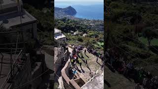
The trail is quite narrow in some places and features irregularly stepped sections, so it's recommended to wear hiking shoes and bring water and walking poles.
Although Falanga is now a forest, until the 19th century it was a large vineyard: the parracine, the dry-stone walls that supported the terraces, still preserve the memory of this past.
Continuing upward, the landscape opens up to the Frassitelli: a peak of Epomeo, an acacia forest... and a wine famous far beyond the island.
From this natural terrace, 600 meters above sea level, the view encompasses the entire Forio area: from Sorgeto to Punta Caruso, with the neatly arranged Biancolella vineyards at their feet, a symbol of Ischia's heroic viticulture, and in the distance the Pontine Islands and the Lazio coast.
Here you can breathe in the most authentic and hidden soul of Ischia. The soul of Tifeo.
In particular, the section that begins or ends in the churchyard of the Church of Santa Maria al Monte, a 16th-century rock church.
From here, you enter the Falanga Forest, a dense chestnut grove where enormous blocks of tuff, shaped by the wind, become true natural monuments. Among them are the Pietra Perciata and the ancient Stone Houses, hand-hewn into the rock to provide shelter for farmers and shepherds.
A little further on, you'll find the rock-cut palmenti, where must was produced for centuries, and the snow pits, deep cavities used to store Epomeo snow during the summer, and a green tuff sculpture depicting the Head of Typhoeus.
The trail is quite narrow in some places and features irregularly stepped sections, so it's recommended to wear hiking shoes and bring water and walking poles.
Although Falanga is now a forest, until the 19th century it was a large vineyard: the parracine, the dry-stone walls that supported the terraces, still preserve the memory of this past.
Continuing upward, the landscape opens up to the Frassitelli: a peak of Epomeo, an acacia forest... and a wine famous far beyond the island.
From this natural terrace, 600 meters above sea level, the view encompasses the entire Forio area: from Sorgeto to Punta Caruso, with the neatly arranged Biancolella vineyards at their feet, a symbol of Ischia's heroic viticulture, and in the distance the Pontine Islands and the Lazio coast.
Here you can breathe in the most authentic and hidden soul of Ischia. The soul of Tifeo.
Indirizzo e punti di contatto
| Title | TIFEO |
|---|---|
| Start Point | Via Falanga, 42, 80081 Serrara Fontana NA |
| End Point | Via Santa Maria al Monte, 80075 Forio NA |
| Length | circa 7 km |
| Time travel | 3 ore |
| Degree of difficulty | Media |
| difference in height | 500 m |
| Recommended period | Tutto l'anno |
| Guides and maps | Il percorso è accessibile con guida o con carte escursionistiche. |
| Information | • Indossare abbigliamento comodo e scarpe da trekking. • Portare acqua, cappello e protezione solare. • Evitare le ore più calde in estate e le giornate di pioggia in inverno. • Il percorso non è adatto a passeggini o biciclette. |
Map
Itinerario in formato GPX
Photo gallery
Numero immagini: 14
-
Pietra Perciata
Monumento naturale -
Vicino Pietra Perciata
-
Fossa della neve
Dove, nei secoli passati, i venaioli stipavano la neve invernale per farne ghiaccio da consumare in estate. -
Sentiero del Tufo Verde
e delle Case di pietra - tratto a gradoni -
Casa di pietra
Una delle tante case di pietra presenti nel bosco della Falanga -
Testa di Tifeo
scultura in pietra verde raffigurante il gigante della mitologia -
Casa di Pietra
Una delle tante case di pietra presenti nel Bosco della Falanga -
Palmento Rupestre
Palmento Rupestre -
Arco in pietra
Arco presente nel bosco dei Frassitelli che apre il sentiero per l'eremo di San Nicola. -
Bosco dei Frassitelli
-
Panorama dai Frassitelli
-
Segnali CAI
-
Panorama dai Frassitelli
verso Panza -
Bosco della Falanga
visto dalla punta dell'Epomeo. Si riconosce la Pietra Perciata
Video galley
Modalità di accesso
Il sentiero presenta tratti stretti e irregolari, non adatti a passeggini, carrozzine o biciclette.